


cathé Christine

rcharlet
User

Length
10.2 km

Max alt
794 m

Uphill gradient
293 m
Km-Effort
14.1 km

Min alt
599 m

Downhill gradient
316 m
Boucle
No
Creation date :
2019-11-13 09:12:12.872
Updated on :
2019-11-13 12:00:55.917
2h45
Difficulty : Very easy

FREE GPS app for hiking
 SityTrail
IGN / Geographical institutes
SityTrail Plus
The world is yours!
About
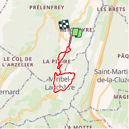
Trail Walking of 10.2 km to be discovered at Auvergne-Rhône-Alpes, Isère, Le Gua. This trail is proposed by rcharlet.
Positioning
Country:
France
Region :
Auvergne-Rhône-Alpes
Department/Province :
Isère
Municipality :
Le Gua
Location:
Unknown
Start:(Dec)
Start:(UTM)
707266 ; 4986159 (31T) N.
Comments